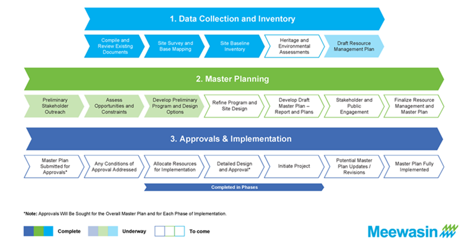
Master Plans

With funding provided by the City of Saskatoon, Meewasin will be continuing with the initial phases of work within the Northeast Swale.
Work in 2021 included additional interpretive and trailhead signage, additional wildlife-friendly fencing and access gates, and ongoing restoration in the recreation zone and adjacent to new trail developments.
Continued efforts in the Northeast Swale will include ongoing conservation programs, including prescribed fires and targeted conservation grazing. Please keep an eye on Meewasin’s social media and newsletter for announcements regarding these projects and more.
Meewasin is working on an update to the Northeast Swale Master Plan that was approved in 2015, to reflect work completed to date, over ten years of conservation data, and an updated north boundary. This update will be undertaken in conjunction with Saskatoon Land’s development of a concept plan for the Sunrise neighbourhood north of the Swale.

If you would like to be notified about project updates, please subscribe to Meewasin’s newsletter in the box on this page.
Saskatoon’s northeast is undergoing significant development as the City grows.
The Meewasin Trail in this area is incomplete, with gaps between Sutherland Beach and Crocus Prairie and to Chief Mistawasis Bridge.
Meewasin is undertaking a process to better understand the area and plan for a comprehensive primary trail network that will reach from the Circle Drive North Bridge to the Chief Mistawasis Bridge. This will include providing backshore trail connections to adjacent neighbourhoods and important features such as the Meewasin Northeast Swale and the Small Swale in the future.
Meewasin has started drafting a conceptual trail alignment for this area, and we want to know what you think! This project will include:
- New and enhanced primary trails
- New backshore trail connections and access points
- New site furniture
- New trailhead and interpretive signage
- New plantings
- New trail lighting
More detailed design and phased construction will be undertaken in future years as funding becomes available.
Drawings and Documents
Learn more about the project and get a glimpse of what's ahead!
Click here to explore the conceptual trail drawings

Important Dates:
Join us for pop-up events to learn more about the conceptual trail alignment and ask questions:
- Saturday, September 19th, 11 a.m. to 3:30 p.m. at the Swale, at the parking lot on Range Road 3050 (during grazing demonstrations), Google Maps Pin Location.
- Wednesday, September 23rd, 4 to 7 p.m. at the Circle Drive Bridge pedway (on the west side, off Pembina Avenue), Google Maps Pin Location.
- Saturday, October 3rd, 1 to 4 p.m. at Sutherland Beach Dog Park entrance, Google Maps Pin Location.
- Thursday, October 8th, 3:30 to 6 p.m. at Crocus Prairie, Google Maps Pin Location.
If you would like to be notified about project updates, please subscribe to Meewasin’s newsletter in the box on this page.
Maple Grove